ESEAS Observing Site (EOS) in Wladyslawowo
Wladyslawowo is the polish tide-gauge station involved into ESEAS, which mainly participates in service as station for monitoring and studies of sea level changes. Collocation of two different types of tide-gauge sensors (two float: old analog, observing since 1948, and the new, fully automated, pressure one - established in April 2003), a new permanent GPS (CGPS) station, absolute gravity measurements and levelling program create conditions to estimate vertical land movements and, on this basis, to determine both: relative and absolute sea level changes for this area.
SITE LOCATION
EOS station is located at the open coast of the sea, in a part of the coast not disturbed by estuarine influences, in the town Wladyslawowo. It is the one of the biggest polish fishery harbours, situated close to the most nortern place in Poland: Rozewie Cape (Fig. 1). This place is also very convenient for covering by CGPS, DGPS and RTK services one of the large rapidly developing areas in this region - the Puck Bay.
The EOS Wladyslawowo station has the following approximate geodetic co-ordinates:
B = 54° 47'8 N + 54.7967°
L = 18° 25'1 E + 18.4183°
 |
|
| Fig. 1. Regional context - Wladyslawowo is located in the Polish east cost, on the Hel Peninsula base. |
 |
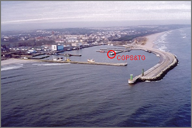 |
| Fig. 2. Local context - EOS station Wladyslawowo is located on the inner quay in Wladyslawowo harbour. | |
SITE DESCRIPTION
In 1938 only a tide staff (rod) was placed in a new harbour in Wielka Wies (now Wladyslawowo), but unfortunately the pre-war observations were lost. In 1947 the observations of sea level were resumed and starting from 1st January 1948, stilling well tide gauge was established in the fishery harbor Wladyslawowo, at the end of the inner pier. (Fig. 2)
You can see current conditions inside the Waldyslawowo harbour Webcam Live!
It should be noted that the localization and zero point were not changed since that time.
The building, in which the mareograph and CGPS are installed, is connected to the electric supply line (AC), digital telephone line (ISDN) and can be easily connected to any telecommunication line. New established (in 2004) gravity station is located 1.2 km from the coastline and from CGPS and TG sensors. All instruments are verticaly connected each other and with selected set of the primary national vertical network bench-marks by means of precise levelling. There is also made such connection with the station 0301 ROZEWIE (in ~6.4 km distance), which is included into several GPS networks like e.g.: EUREF-POL, POLREF and EUVN.
Station participation in national and international programs, research projects and services:
- ESEAS-RI (since 2002-11-01 to 2005-10-31)
- ESEAS service (since 2002-11-01 to ---)
- PSMSL Nr 110047 (since 1951-01 to 1999-12)
- ASG-EUPOS service: WLAD station (since 2008-06 to ---)
The following two polish institutions take care of proper and failure-free work of this EOS station:
Wladyslawowo station in ESEAS network
Below You can see the location of Wladyslawowo station on the map of ESEAS stations (for the end of October 2005)
 |
| Fig. 3. Map of ESEAS Observing Sites. Blue circles: Tide Gauge, red circles: CGPS, orange circles: Episodic GPS measurements, violet: Absolute Gravity stations. |
Last updated on: 2005-10-25 by Ryszard Zdunek
| This website is sponsored by EU Project Nr.EVR1-CT-2002-40025 - 'ESEAS-RI' and SPUB-M KBN 'ESEAS-RI' |