Continuous GPS (CGPS) Station
Previous GPS measurements performed in Wladyslawowo
Until April 2003 no permanent GPS stations were located near tide gauges in Poland. GPS measurements were only made during national or international GPS campaigns. One of the largest projects for mean sea level studies was the Baltic Sea Level Project, established in 1989 as IAG SSG 5.147. Within this project three GPS campaigns were organized:
- in October 1990
- in June 1993
- in May 1997 (as densification of the EUVN97 GPS Campaign in Baltic Sea area)
In a frame of ESEAS-RI Pilot Project, permanent GPS station (CGPS) was establish near tide gauge in Wladyslawowo (on the roof of the building, were the tide gauge sensors are located). This new location, more convenient for both: GPS operating in permanent mode as well as for GPS collocation with tide gauge sensors, is within only few tens of meters distance from GPS marker used during BSL Project. In the distance of ab. 6.4 km EUREF station (301 Rozewie) is located. These three points were connected verticaly using independently: GPS and precise levelling measurements.
Receiver / Antenna type
In January 2003 following GPS equipment was purchased (partly funded by EU - 'ESEAS-RI' Project, partly by polish government - SPUB) for establish CGPS station near tide gauge in Wladyslawowo:
- receiver type: Ashtech uZ-CGRS
- antenna type: Ashtech DorneMargolin Choke-Ring ( ASH701945E_M SNOW )
The receiver is equiped with 128 MB Flash type internal memory and can operate in DGPS/RTK modes with high time resolution.
During that Spring some works concerning the establish of new monument for GPS antenna were performed. It was constructed on the roof of the tide gauge building in a form of a pillar. Special hole was done in this pillar in order to take easy and precise control measurements (using calibrated rod with scale) between Antenna Reference Point (ARP) and the GPS bench-mark, established in the wall just below the pillar.(Fig. 3). During some test measurements, performed before the selection of final location of GPS station we've observed some potential problems concerning birds behaviour towards the antenna, so finally we decided to intall so called 'Snow Cover' (Fig. 3). From Fig. 2. we can see that GPS antenna can observe in clean horizon for elevation above 0 deg, with very small obstructions (below 5 deg) in N-N-W direction. However, occasionally it can be surrounded by small sailing boats' or fishing cutters' masts.
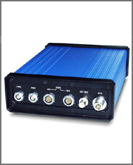
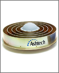 Fig. 1. GPS equipment installed on CGPS station:
'Ashtech MicroZ-CGRS' receiver and 'Ashtech Dorne-Margolin Choke-Ring' antenna (with 'Snow Cover').
|
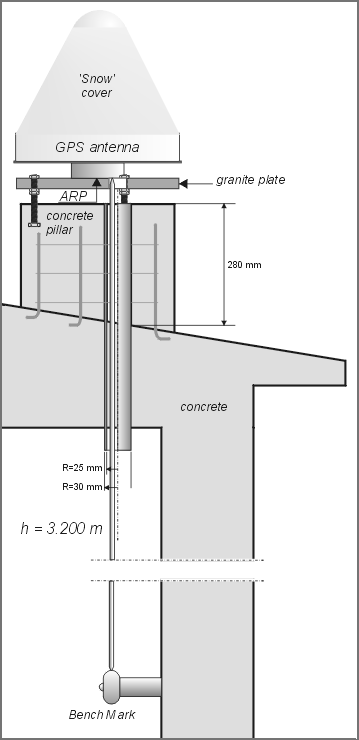 Fig. 3. GPS antenna is located on the roof of the tide gauge building just above the CGPS reference bench-mark, installed in the wall of the building. |
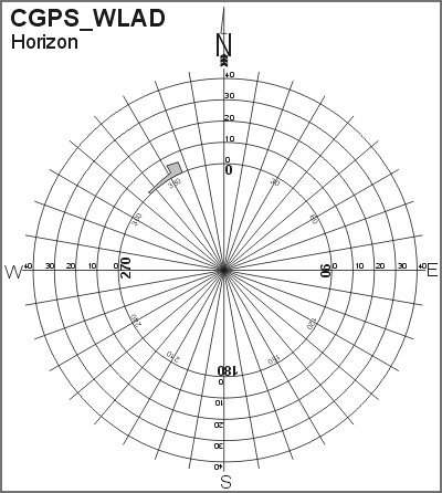 Fig. 2. GPS antenna horizon is clean for elevations above 5 degrees.
- data collecting interval: 30 seconds (5 seconds data are transfered for ASG-EUPOS since 2008-06-20)
- elevation cut-off angle: 5 degrees
- smoothing code observ.: disabled
Observations are stored in internal memory of the receiver - currently in a form of a daily session files. Simultaneously they are transmitted via RS-232 interface to the PC and archived on it's hard disk drive. Each day the data are sent by Internet to the SRC in Warsaw, where they are converted to RINEX, checked using teqc and qcview32 programs, compacted (using Hatanaka alghorithm), compressed and archived on CD/DVD-Recordable discs. They are also uploaded, on the daily basis, to the ESEAS CGPS data server. Paralelly, since 2008-06-20, 5-seconds data are send to ASG-EUPOS servers.
| Last updated on: 2008-06-20 |